「RENOSY(リノシー)」サイトは、中古マンション取引データから独自の規則性を学習したAIが算出した推定価格や、エリア毎の犯罪率や世帯属性の可視化、近隣の病院や学校などを地図上にマッピングした近隣マップなど、多様なデータの活用により安全で透明性の高い不動産取引を目指しております。この度、新たに地震や豪雨などによる地盤液状化・洪水のリスクを可視化したことで、災害リスクも考慮した家探しが可能になります。
背景:災害リスクの備え
東日本大震災以降、消費者の災害リスクに対するニーズは高まり続けており、2017年には「住宅購入の際に意識すること(※1)」の上位に地耐力、地震の揺れやすさ、浸水の可能性と災害に関する項目が続きました。
また、西日本豪雨が起きた2018年には土砂災害の被害件数が過去最多(※2)の約3,400件を記録し、各地自体や国土交通省は防災に役立つ様々なリスク情報やハザードマップを提供し、災害時の迅速な避難に備える取り組みがなされています。
このような背景を受け、当社では、災害リスクを考慮したお家探しをより手軽に可能にするべく災害リスクマップを開発いたしました。これにより住宅のスペックだけでなく地域の災害リスクを絡めた家探しが可能となり、最適な保険や防災の検討にも貢献いたします。今後は、避難場所や人口密度などより豊かな情報を提供していくことで、ユーザーの理想の家探しをサポートしていく所存です。
(※1):一般社団法人全国住宅技術品質協会「住宅の購入や地盤に関する意識等についての調査」
(※2):国土交通省 水管理・国土保全局 砂防部保全課 土砂災害対策室 http://www.mlit.go.jp/common/001267056.pdf
ニュース一覧
関連ニュース
-
![]()
AI不動産投資RENOSY、6/21(土)に川崎フロンターレの冠試合 「RENOSY エキサイトマッチ」を今年も実施
- プレスリリース RENOSYマーケットプレイス事業
-
![]()
AI不動産投資のRENOSY、「性格でわかる!?あなたの投資スタイル診断」を開始
- プレスリリース RENOSYマーケットプレイス事業
-
![]()
AI不動産投資のRENOSY、ブランドコンセプト実現に向けた 行動指針「Asset Planner’s Tenets」を制定
- プレスリリース RENOSYマーケットプレイス事業
-
![]()
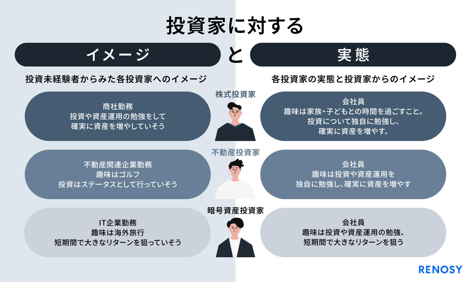
AI不動産投資のRENOSY、「投資家“イメージ”と“実態”調査」を実施
- プレスリリース RENOSYマーケットプレイス事業
-
![]()
AI不動産投資のRENOSY、顧客満足度向上のため オーナー、入居者向けシステムを刷新
- プレスリリース RENOSYマーケットプレイス事業
-
![]()
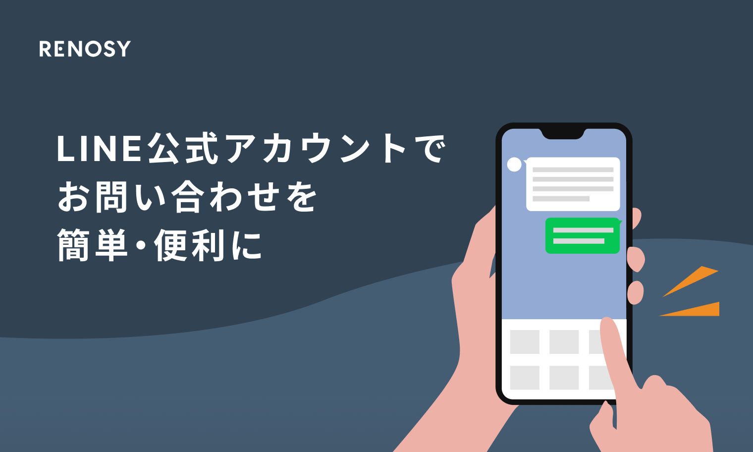
AI不動産投資のRENOSY、オーナー・入居者向けLINE公式アカウントに AI-Chatbotを導入し、お問い合わせをより簡単・便利に
- プレスリリース RENOSYマーケットプレイス事業